Thursday, July 5, 2012

June 20, 2012 - My Highest High

Comfort Inn in Bishop, CA
Todays Miles: 22
Trip Mileage: 96

Another amazing day, thanks to a pair of feet that have finally (hopefully) accepted that this trip is happening whether they like it or not. We woke up this morning at  5:30 and hiked merrily toward Forrester Pass. Well, Andrew hiked merrily. I shoved my hands in my pockets and let my poles drag behind me, trying to hike myself warm. It's hard to stay uninspired with the high Sierras jutting up around glassy alpine lakes, and a deliriously happy, scruffy hiker guy singing Disney musicals in front of you. Andrew is the best motivational hiking partner ever.

I'm not a talented enough writer to to describe Forrester Pass, or anything that came after. Just be glad I took pictures. I couldn't believe Forrester Pass was Forrester Pass as we approached, just a jagged knot on a sharp ridge. But that's where the switchbacks led us, well beyond the point I thought a mountainside could accommodate a trail. Trail builders are a remarkable breed. So are the hikers that hike those trails, for that matter. The feeling of elation I had after reaching the top is indescribable. I realized that I was a) standing at the highest point point I'd ever been at, and the highest point I'd ever be on the PCT; and b) the scene was so breathe-taking I, I felt no pain anywhere in my body. That phenomenon was repeated several times on today's hikes, hence the 22 miles and two passes I was able to achieve without crumpling. Nature's magnificence can be a very effective pain reliever.

So we hiked over Kearsarge Pass (a treat we get to repeat after our day in town) into Onion Valley Campground, where an enterprising and entertaining trail watcher named Paul gave us a ride to Independence. That's where we crossed paths again with Challenger and Just-A-Test, who were easily convinced to join us on the bus to Bishop, land of Schatz Bakery and untold other glories.

Shaggy says:

We woke up early. The sunrise was amazing. Camping up high is the way to go, no bugs, and amazing views. We sang songs the first mile, I was stuck on some great Disney songs, the bear necessities in particular.
  Forrester Pass was a good workout. Its the highest spot we will ever hit on the PCT, and is really beautiful. Last time I was there, I glissaded down the other side. This time we had one patch of snow, and it was about 10 feet long. No way to get lost, or even off trail. One really nice thing about the lack of snow is the flowers. On the top of Forrester these little blue flowers were intoxicating. I could not get enough of the smell!
  After Forrester was the long, slow decent into the valley below. So beautiful though. Lauren decided about this point that she wanted to hike over Kearsarge Pass, and down into Onion Valley, trying to get to Bishop tonight. We made it too! 22 miles, 2 passes, amazing views all day.
  We caught a ride down to Independence very quickly, there was a car leaving, just as I reached the bottom. Then we caught the 5 PM bus to Bishop. Challenger and Just a Test joined us, and are staying in the same hotel. We ate dinner together and now may all take a zero tomorrow. I love Bishop... cheesebread is amazing. It is so hot down here though, probably close to 100. Time to rest.

"I notice well that one step from the habitual path leads irresistibly in a new direction."

The sun crept slowly over the mountain. Very slowly...my hands stayed in my pockets until I reached the switchbacks of Forrester Pass.

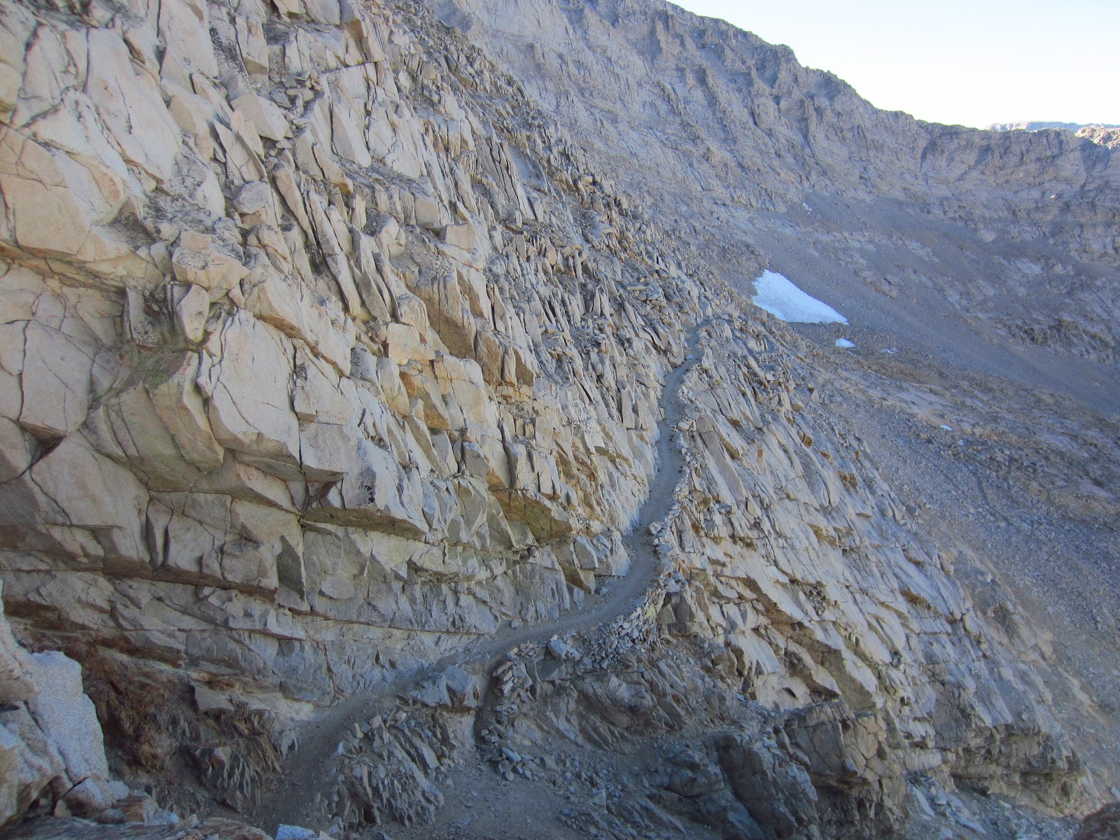
Look at the bottom left corner of this picture. Now slowly look up until you see a VERY tiny black  speck in the rocks. That's Andrew. And that crevice he's walking toward is Forrester Pass. For reals.

I'm often in awe of the work that goes into building these mountain trails, but this plaque gave me a new appreciation. Thank you, Donald I. Downs.

Sky Pilot became my new favorite flower because it grew only at the highest, rockiest passes and smelled like sweet cotton candy.

The reflection of Forrester Pass looks almost as bad-ass as the pass itself.

A very unusual sight: Forrester Pass with almost no snow. This is normally a heart-pounding crossing of a steep snow slope, one few people would attempt at 7am like we could this year.

Imagine blasting and scraping away this trail. I'm very thankful.

Andrew finds a rockbar and shows off his trail-building skills. We'll make our own trail to Canada!

My highest elevation ever, until I conquer Whitney on my next visit.

Suncups! So glad we didn't have to hike through any of these.

Once we crossed Forrester Pass, we were in another world. I love this world.

Bullfrog Lake, en route to Kearsarge Pass. This may have been our hardest, and my favorite, day of hiking in the High Sierras.

View from Kearsarge Pass. Thankfully, we got to do this trail again on the way back from Independence (Kearsarge isn't on the official PCT)

Shaggy leading the way over Kearsarge.

A jeweled tarn on the other side of Forrester.

Coming down the Pass into Onion Valley. Yes, you want to go there.

June 19, 2012 - Fear the Pika

Two miles from Forrester Pass
Elevation: 12,200 feet
Today's Miles: 12
Trip Miles: 74

If there are even a few more places like this on Earth, then we have been spoiled. Since walking up to Bighorn Plateau, with that single tiny topaz lake, surrounded by sharply-cragged mountains, the views have only gotten more unbelievable. Taking pictures seems futile, since they never come close to the real thing, and when I write about it I always seem to run out of adjectives. So I guess everyone will just have to come see the Sierras for themselves.

I added a few critters to my witness-to-wildlife list today. A funny little bird, beautiful little grey-blue thing, would streak alonf the creek a few inches above the water, stop on a rock to hop up and down a few times, then do it all again, peeping a high-pitched tune the whole time. I'm sure he was catching bugsm but he had a very entertaining way of doing it. We also saw several marmots, which look like woodchucks trying to be wolverines, all chubby and waddling in their beautiful brown-gold fur. They're not very afraid of humans, unless you make the high-pitched squeak of a pika, which sends them scurrying into their marmot holes. The pika is a chipmunk-sized critter that will loudly declare its ownership of whatever rocky terrain you happen to be walking through. It also has razor-sharp teeth capable of shearing through a food sack quicker than you can say bear canister. The marmots are wise to fear the pika.

We'll make it to Bullfrog Lakes tomorrow without a problem, and if my feet are still talking to me we'll start down Kearsarge Pass.

Shaggy says:

We decided last night that we would take an easy day, not going up Whitney meant we had time to do whatever. So this morning we slept in. Then Lauren went walking down the creek, while I walked up creek for awhile. I was trying to catch some trout with barehands, but no luck. Then I started to look at maps and got anxious. We are doing great, 12-18 miles a day, but its still hard for me to stay still. It will likely be this way for awhile too, waiting for Lauren's flat feet to get stronger. I dont know why I get anxious. It may have to do with all of the other hikers constantly passing us. Not to sound like a jerk, but normally not many hikers pass me.
  We did good though today, 13 miles after noon. We are camped about a mile or so from the top of Forrester Pass, the highest point on the PCT. Views are incredible. Its going to be a cold night though, up here at 12500 feet.
  We only have 20 miles to Onion Valley, where a hitch will take us to Bishop. But we may do it in 2 days, depending on how the feet hold up. Time for rest.

Climbing up, up, up and into the meat of the High Sierras!

Pretty neat, if you like trees, rocks and dirt...

Every now and then I'd turn around to see Shaggy snapping a picture of me. There are MOUNTAINS to capture, man!

Near our campsite before Forrester Pass. See that crack between two ridges, just right of center? That's Forrester.

Eggshell that wanted to be photographed.

Our campsite was relentlessly scenic, but we try not camp on these fragile tree-less areas.

I love this picture. It's like our bear canisters are enjoying a quiet moment together while the sun sets.

The very first patch of (nearby) snow we saw on our trip. It measured roughly 5 ft x 10 ft.

June 18, 2012 - Of Wind and Whitney

Crabtree Meadows, below Mt. Whitney
Elevation: 10,500 ft
Today's Miles: 16
Trip Mileage: 62

Today felt good. We had mostly easy miles, with some very steep but short stretches then a steep drop into this meadow with a ridiculously picturesque creek winding through it, Mt. Whitney looming over all. The boulder pile I'm sitting on now is warm from the sun and looks down on a little waterfall pool where fish dart around. Not bad for a Monday.

I am disappointed to be so close to the highest peak in the lower 48 states, and not climbing it. I could pull it off, all 18 miles and 4,000 feet of elevation gain, but the aftereffects would be unknown, likely unpleasant. Just a few miles of downhill today made my arches ache - Whitney's switchbacks make them quiver in fear! If only the whole PCT could be uphill, I know I"d be fine.

We've met more of the full-distance (started at Mexico) thru-hikers here. Just-A-Test stopped at Chicken Spring Lake just as we were leaving it and then we met formally here at Crabtree Meadows, where we're all camped for the night. She commented on Chicken Spring's obvious beauty and lamented not camping there last night. There was definitely beauty, and cold water for swimming and frogs for singing you to sleep, but there was also a major wind situation at night. Out tent kept us up with its constant flapping and the wind with its loud howling. Then around 3am the tent collapsed, and we slept peacefully with ti over us like a blanket, thankful for the quiet, while the wind howled itself to sleep.

Anyway, I didn't relay any of this to Test, because I was too distracted by mosquitoes. They've finally made an appearance (even though there is still NO snow to melt into puddles for them) although they don't seem very motivated to fight for our blood. Challenger (another PCTer) came down from Whitet just then, glowing from a day of powering up and down the 14,504 foot peak. His was the funniest reason I've ever heard for summitting a peak: he needed cell reception to pay a bill that would be due before his next town stop. Just one more way technology is changing the way we hike.

Just-A-Test had an even better trail-meets-technology story. She accidentally (and unknowingly) set off the 911 function of her Spot GPS emergency beacon. For those who don't know, a Spot is one way a hiker can call in the cavalry when far from roads or phones. And the cavalry did come for Just-A-Test. She said she could see a helicopter circling for a while before she got suspicious, check her Spot and sheepishly called off the search (she was actually at a campground which had cell reception). She was only three days in the PCT, so of course she immediately received her trail name: Just-A-Test. I'm still waiting on mine, and any story that might come with it.

Shaggy says:

Woke up many times last night to the wind flapping the tent around. Finally it was so strong it pulled a stake out of the sandy soil, and the tent collapsed on us. It took us awhile to give in, but we finally decided to take the tent down and sleep under the stars. They were beautiful too. Not sure why we didnt do that at first!
  We started late due to the lack of sleep. The trail was beautiful today. I was really surprised that we didnt see anyone else while hiking today. It seems like the PCTers are really spread out this year, likely because of the lack of snow.
  We made it to Crabtree Meadows by 430. Camping really early to let Laurens foot rest. It is beautiful here, I love the Sierras. The view from my tent yields a meadow with stream running through it. Deer are in the meadow, chowing down. The mountains in the background are huge slabs of granite jutting up from the ground. Whitney is one of them. Right now we are considering an easy day  tomorrow, give Lauren time to rest her foot. I may opt to climb Whitney, unsure right now.

"The tragedy of life is not what we suffer but rather what we miss."

Zero was all for a long break at the creek to soak his...um, wings.

Bouldery creek that I once knew the name of. One of the raging creek crossings we had to deal with...

The mighty fisherman stalking his prey.

Lightning-quick hands catch fish for dinner! Well, they would if the fish had been any bigger than sardines.

Not sure which one is Whitney (it might be in the back) but I still stared longingly in its direction while I rested aching feet.

Deer grazed in the meadow beneath Whitney, begging someone to paint the scene.

On my solo-explore morning, I followed this creek full of tumbling waterfalls.

Even Zero was speechless near this cascade - it was deafening!

June 17, 2012 - Swimming in Spring Chicken

Chicken Spring Lake, camped at the base of  a mountain
Today's Miles: 15
Trip Mileage: 47
Oh, alpine lakes; who needs heaven when you have an arc of stone cliffs, dotted with snow banks and pines; a see-to-the-bottom sapphire lake with a fine gravel shore that begs you to wade in. Sigh. I went for a (very) cold swim when we made camp, and now that the sun is going down I don't think I was to leave tomorrow. I know I'd get anxious to hike after a few hours but it's nice to fantasize about a long sunny day at the lake. Some younger people are doing just that - Hwy 395 isn't far from here and it looks like a lot of people camp long weekends here. Some kid in neon shades even gave me some Jolly Ranchers. My first trail magic!

Hiking today was stop-and-go for me. My arched are becoming more insistent that this long-distance hiking thing is not what they agreed on. I thought I could go at least a week before my feet affected my distance but apparently they require my immediate attention. Today we wrestled with the question of whether to keep our course to Mt. Whitney and then hike over Kearsarge Pass, or to drop down to Horseshoe Meadows this morning and get a ride to Independence. The idea was I'd buy a new, hopefully more supportive pair of shoes there and take a few easy, low-mile days. After much torturous indecision, my aversion to a hotel and civilization, after only three days out here, won out out over my aching feet. But I did concede Whitney, knowing that the tough climb might be too much too early, and the time we save by skipping it means fewer miles each day. So, my first difficult decision on the PCT: done. We'll see how it works out.

Shaggy says:

Today we hippied it up. We walked 14 miles to a lake and while Lauren swam, I did some stretching (yoga). This lake has some cold water in it. This didn't stop Lauren from swimming to the middle and back, I will tip my hat to that.
  I didn't sleep super well last night. Drank a lot of water before bed, so was forced up a couple times. Sometimes its so hard to get up though. So comfy wrapped up in my down bag. Its also strange to me to be camped near a large group of folks, and several were gone before daybreak. We followed shortly, leaving just after 7 AM.
   The Sierras slowly showed their true colors today. The colors are mostly grey! No snow, except in tiny patches high in the mountains. The meadows are really green still, but I suspect that even the greenest of meadows will die this year as well. It makes me wonder about a few things. Will the bears be more actively searching for food? Will there be fires on the trail further north? And most importantly, will there still be berries up north? These questions and more ran through my head today along the dusty trail, only time will answer them.
   Lauren's feet were a big part of our discussion today. Her feet have bothered her everyday so far, but mostly after yesterday's 18 mile day. I wish we could have trained for this more, hard to get big mileage days in winter, but we should have tried. We debated for awhile if we should go into Lone Pine today so Lauren could find new shoes and rest up her feet, but we opted not to. Instead we will try to hike slower and skip hiking Whitney in a few days. I have done Whitney before, and Lauren says shes ok skiippin it. So we will. I just really hope her feet can handle the beating that our feet are in for. The numbers are frightening. 2000 miles in just over 100 days. But anything can happen. Tonight we will enjoy Chicken Spring Lake.